- 1 · The plan
- 2 · Today
- 3 · Roads going in
- 4 · Under the streets
- 5 · Buildings
- 6 · Three years
- 7 · Side by side
- 8 · Finished · AI
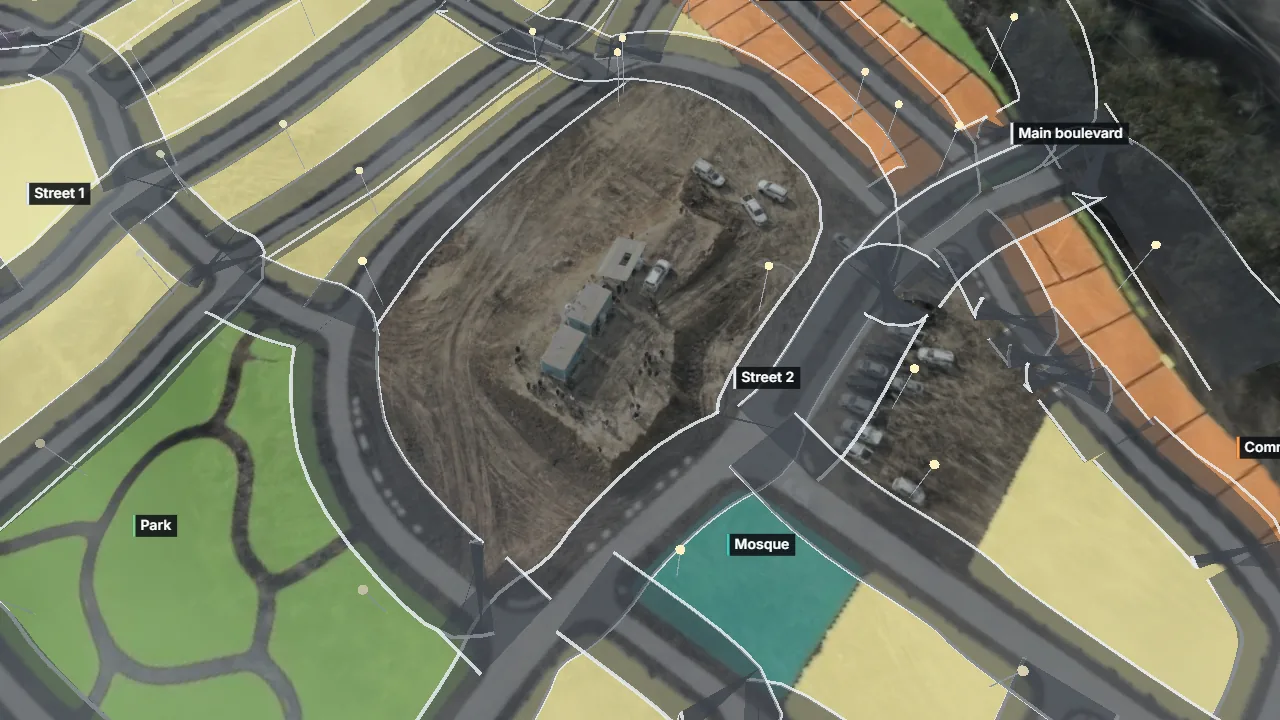
Developers sell a society long before there is anything to see: a site office, graded earth and a brochure. We took one stock drone orbit of a site in Pakistan on its first day and rebuilt it in 3D, then drew the plan onto the ground itself. An AI draws a masterplan over a straight-down picture of the site made from the footage, so it lines up with the real land; from it come the streets, the park, the mosque and school sites and the shops along the boulevard, with plots fitted at real 5 marla sizes. Under every street run a sample of water, sewer, power and Sui gas, with street lights every 30 metres, and the page adds it all up. Every plot and site then gets a simple model building, the houses, a mosque, a school, three rows of shops and the water tank, and a click on any one gives its size, structure, services and build time. A timeline builds the society phase by phase, roads first, then the services, the plots and the houses, and from where the drone stood, a divider slides between the 3D and the AI's pictures of the same view a year and three years on.
What we tried
- One 43-second 4K stock orbit of a new society site in Pakistan: 172 frames, every camera placed (0.47 px average error), rebuilt in 3D with up to 1.5 million splats.
- A straight-down picture of the ground made from the drone frames themselves, each point taken from the nearest frame that saw it.
- An AI image model asked to draw a masterplan over that picture, in the same framing, so it lines up with the land; asked again with the real scale in pixels when the first plan came out far too dense.
- The plan read back by colour: blocks, a park, a mosque, a school, shops and a water tank, and 2.2 km of streets thinned to centre lines and smoothed.
- Real 5 marla plots (25 by 45 ft) fitted into the AI's blocks, and a sample services plan along every street: water, sewer, power, Sui gas and street lights every 30 m.
- A simple model building on every plot and site, sized from the plan, each with a card: size, structure, services and a sample build time.
- A phase timeline, and two AI pictures of the same drone frame a year and three years on, laid over the 3D from that drone position with a divider to drag.
What we measured
| Measure | Result | Note |
|---|---|---|
| Frames placed by the camera solve | 172 of 172 | 0.47 px average error, a 283-degree orbit |
| Held-out frames, rebuilt vs real | 37.7 dB PSNR | SSIM 0.952 |
| Ground mapped | 272 m square | about 146 kanal; scale from parked cars, about plus or minus 15% |
| Plots fitted at real size | 61 | 5 marla, in the AI plan's blocks |
| Streets traced | 2.2 km | with 69 street lights and four services along each |
| AI pictures | 4 for $0.27 | two masterplans (the first not to scale) and two views of the future |
| Browser download | 20 MB | the site in 3D |
What went wrong
- The first masterplan looked right and was badly out of scale: plots of about 3 by 5 metres on this land. Telling the model the scale in pixels helped, but its plots were still about 1 marla, so real plots are fitted into its blocks instead.
- From straight above, the soft splats that stand in for the distant sky sit between the camera and the ground, so the top-down picture is made from the drone frames, not rendered from the 3D.
- Reading streets from the drawing first found only the edges of each street and cut them into fragments; thinning the clean grey street pixels and walking them into lines fixed it.
What happens next
- A developer's own approved layout and service drawings in place of the AI plan.
- A flight a month, so the phases show what has really been built.
- The picture of the finished society lifted into 3D in place, as in the Giza demo.
Built with
- Gemini image model (masterplan and future views) Google API terms
- OpenCV (reading the plan) Apache-2.0
- Spark 2.2 MIT
- three.js MIT